Capstone

Two women sitting at an outside table enjoying coffees

Capstone

The area of Capstone has always been a part of Red Deer, and we now have a rare opportunity to develop it into a flourishing community. Near the burgeoning downtown core, this urban community will combine every convenience of life, work and play into one central location.

Download the Capstone Area Redevelopment Plan (pdf)

Visit LiveInCapstone.ca now!

January 2026 Proposed Capstone Changes

The City is proposing changes to the Capstone Area Redevelopment Plan (ARP) and Zoning Bylaw 3357/2004 - Part 10: Capstone Zones and Regulations that would affect future development in Capstone. These changes would:

  • Rezone land to reflect current or planned open spaces
  • Reflect new property lines on City lands
  • Reduce red tape
  • Provide clarity in regulations
  • Provide more flexibility in development
  • Continue to encourage active and lively streetscapes and public spaces

What changes are proposed?

The City is proposing changes (also known as amendments) that include:

  • Rezoning of public lands for open space that reflect new property lines on City lands
  • Removing movement corridors
  • Revising the Active Commercial Main Floor Overlay
  • Simplifying edge zones

These changes also result in small updates to other sections of the Bylaw, which have been included for consistency. Details of the proposed changes are listed below for clarity.

Files

Details of Proposed Changes

1. Rezoning of public lands for open space that reflect new property lines on City lands

All land within the city is assigned to a land use zone except for roads. Zones provide the rules that determine what can and cannot be built or operated on a site.

The City is proposing to correct the zoning on lands used for public open space. The proposed zoning aligns with the Capstone ARP vision and is considered a minor housekeeping amendment.

Subdivision of City lands north of 47 Street occurred in October 2025, this subdivision created new property lines. Mapping in the Capstone ARP and Zoning Bylaw will be adjusted to reflect the new property lines.

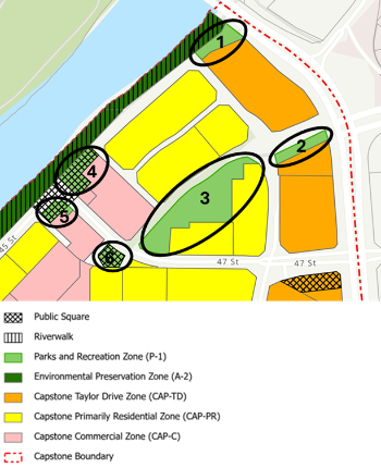
The proposed zoning changes are circled black in the image below.

  • Areas 1 and 2 are proposed to be rezoned P-1 Parks and Recreation Zone from CAP-TD Capstone Taylor Drive Zone
  • Area 3 is proposed to be rezoned P-1 Parks and Recreation Zone from CAP-PR Capstone Primarily Residential Zone
  • Areas 4, 5 and 6 are proposed to be rezoned P-1 Parks and Recreation Zone from CAP-C Capstone Commercial Zone
Existing Capstone ARP Land Use Zones Proposed Capstone ARP Land Use Zones
Existing Capstone ARP Land Use Zone Proposed Capstone ARP Land Use Zones

The following table provides a brief explanation of each of the zones affected by the amendment and the key information for each zone.

Zone Key Information
P-1 Parks and Recreation Zone This Zone provides land for parks and recreation areas and facilities for the use and enjoyment of the public.
CAP-TD Capstone Taylor Drive Zone The Capstone Taylor Drive Zone functions primarily as an office or Commercial transition area between the historic downtown, the Red Deer Regional Hospital, and the Residential area in Capstone. Due to the proximity of this Zone to the historic downtown and the Red Deer Regional Hospital, the emphasis of this Zone is on office and Commercial uses, with a mix of Residential Dwelling Units. Office or Commercial uses must be a component of any Principal Building in the Capstone Taylor Drive Zone.
CAP-PR Capstone Primarily Residential Zone The Capstone Primarily Residential Zone is to allow a mix of Residential housing types, with Commercial uses compatible with the primarily Residential function of this Zone. Residential Dwelling Units must be a component of any Principal Building in the Capstone Primarily Residential Zone.
CAP-C Capstone Commercial Zone The Capstone Commercial Zone functions primarily as a Commercial and office area with limited Residential to reflect the existing Commercial and office uses occurring in Cronquist Business Park.

More detailed information on each of the zones can be found in Part 9 and 10 of the Zoning Bylaw.

2. Removal of Movement Corridors

A movement corridor is a corridor that facilitates travel for all modes of traffic, such as motor vehicles, bicycles, and pedestrians.

The Capstone ARP shows movement corridors where existing roadways are located and through private property. Movement corridors through private property are encouraged at the time of development or redevelopment. Since the Capstone ARP has been adopted, no movement corridors have been developed on private property. On public property, movement corridors have often been varied as the locations do not always align with development plans for a site. As a result, regulations for movement corridors have created confusion on how and when to implement. This amendment proposes to remove all movement corridors from the Capstone ARP and Zoning Bylaw and replace them with a map showing road locations.

The existing movement corridors are:

  • Riverfront – movement corridor between the river and river-fronting properties.
  • Urban Corridors – operate as the main vehicular road connectors into the Plan area and are generous in size to accommodate all modes of transportation.
  • Green Spine – will operate as the main north-south movement corridor within the neighbourhood.
  • Local Connectors – a street developed narrower than that found in Urban Corridors and serves as the main vehicular north-south connector with no direct access to or from Taylor Drive.
  • Neighbourhood Connectors – a movement corridor narrower than that found in Local Connectors.
  • Residential Mews – the narrowest type of movement corridors and similar to Neighbourhood Connectors may serve as a casual play area, gathering spaces and may be achieved through edge zone development.

The images below show what is currently in the Capstone ARP and what is proposed to replace it. The proposed Movement Concept Plan identifies existing and future roads, all of which are on public land.

Existing Capstone ARP Movement Corridors Proposed Capstone ARP Movement Concept Plan
3. Revisions to Active Commercial Main Floors Overlay

An Active Commercial Main Floor is a commercial space located on the main floor of a building which encourages lively streets and public spaces. Attributes usually include patios, transparent store fronts, window displays, or outdoor seating, with common uses such as coffee shops, art galleries, or boutiques. An Overlay is an additional set of development regulations that apply to specific areas; these regulations are in addition to regulations that already apply to a broader area. This specific overlay requires active commercial main floors on certain sites and locations within Capstone, mostly along the riverfront and on corner sites.

It is proposed that the requirement of commercial main floors in specific locations would be replaced with the encouragement of commercial main floors throughout Capstone. This would add flexibility for the developer by not being restricted to a certain location on the property. On City-owned lands where commercial main floors are desired, the City would have the ability to require commercial uses in the land sales agreement with future landowners.

The existing image below shows the current locations where active commercial main floors are required. This would be replaced with a Capstone neighbourhood map, indicating that active commercial main floors would be encouraged throughout the neighbourhood.

Existing Zoning Bylaw Active Commercial Main Floor Overlay Proposed Zoning Bylaw Active
Commercial Main Floor Overlay

Existing Zoning Bylaw Active Commercial Main Floor Overlay

The existing locations would be
replaced by encouraging active
commercial main floors throughout
Capstone.

Proposed Zoning Bylaw Active Commercial Main Floor Overlay

The Capstone Active Commercial Main Floor Overlay can be found in section 10.30 of the Zoning Bylaw.

4. Simplified Edge Zones

An Edge Zone is where the spill-out functions of a development occur - between a building and a road or public space. These typically contain a seating area, public art, or garden.

The Zoning Bylaw shows edge zones to align with movement corridors, often in the middle of and between private properties, not always where landowners want to encourage spill-out activities. Because it is proposed to remove movement corridors; it is also proposed to remove several edge zones. Other edge zones located along a trail or open space are proposed to be removed as this public space already serves the intent of encouraging public interaction. The only ones that would remain are those along a road; this would allow active and lively streetscapes to continue to be developed along the most visible areas of Capstone.

The images below show the existing and proposed edge zones. The edge zone regulations are found in section 10.20 of the Zoning Bylaw.

Existing Zoning Bylaw Edge Zones Proposed Zoning Bylaw Edge Zones

Do you have comments?

It is optional to provide comments. If you wish to provide comments, please submit them by 4:30 p.m. on Thursday, January 29, 2026. All comments provided will form part of the public record and will appear on a Council Agenda in the same format they are received. In accordance with The City’s Procedure Bylaw, anonymous comments will not be forwarded to Council and personal information will not be removed. 

Comments can be submitted by one of the following methods.

  • Email: planning@reddeer.ca
  • Mail: City Planning & Growth, Box 5008, Red Deer, AB T4N 3T4
  • Drop off at City Hall: City Planning & Growth, 4914-48 Ave, Red Deer, AB

What are the next steps?

It is expected that the changes will be brought to City Council for their consideration in the first half of 2026. There are three steps in the Council process.

  • Step 1: Council reviews a report and administration’s recommendation when considering First Reading. If First Reading is granted, the application moves onto step 2.
  • Step 2: A Public Hearing is held where the public is given an opportunity to speak directly to Council about a proposed change. Public Hearings are advertised on the City’s webpage at Upcoming Public Hearings - The City of Red Deer. Once the Public Hearing is closed, the application moves onto step 3.
  • Step 3: Council considers Second and Third (final) Reading of the proposed change.

Questions?

City Planning & Growth
planning@reddeer.ca
403-406-8711